ShipAtlas by Maritime Optima
- Productivity
- 5.0.0
- 156.09M
- Android 5.1 or later
- Feb 19,2025
- Package Name: com.maritimeoptima.production
ShipAtlas, developed by Maritime Optima, is an indispensable tool for anyone interested in vessel tracking and maritime operations. Leveraging real-time AIS data from over 700 satellite and terrestrial sources, it provides comprehensive tracking capabilities and valuable insights into global maritime activities. This includes detailed information on trade routes, port operations, sea lanes, weather conditions, ice formations, piracy hotspots, and detailed marine charts. The app continuously gathers and processes raw AIS data from the global merchant fleet, ensuring high-data quality. Its features extend to vessel and port searches, sea route calculations, customizable vessel lists, real-time tracking, notification settings, and daily maritime updates. The app boasts an intuitive interface, cross-device data synchronization, and dedicated customer support.
Key Features of ShipAtlas:
-
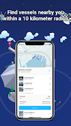
Complete Maritime Data: Access detailed information on port activities, shipping lanes, marine weather forecasts, ice conditions, piracy risk areas, and nautical charts.
-
Superior Data Quality: Rigorous data processing ensures the accuracy and reliability of the AIS data presented.
-
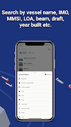
Advanced Vessel Search: Locate vessels using name, IMO or MMSI numbers, or port details. Refine searches using parameters like length, beam, draft, and year of construction.
-
Sea Route Planning: Quickly calculate estimated time of arrival, distance (nautical miles), time at sea, and projected fuel consumption for various routes.
-
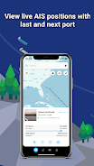
Dynamic Vessel Monitoring: Create unlimited vessel lists based on your search preferences and monitor their positions on the map in real-time.
Summary:
ShipAtlas by Maritime Optima offers a user-friendly platform for accessing real-time AIS positioning data and a broad spectrum of maritime information. Its high-quality data, intuitive interface, and powerful features, such as the sea route calculator, make it an invaluable asset for maritime professionals and enthusiasts alike. While many features are free, a paid subscription unlocks enhanced capabilities. Download ShipAtlas today and embark on a journey of maritime exploration and discovery. For more information, visit our website.
ShipAtlas est un outil fantastique pour l'industrie maritime. Les données en temps réel et le suivi sont excellents, mais l'interface pourrait être plus conviviale.
ShipAtlas es una herramienta excelente para el sector marítimo. Los datos en tiempo real y el seguimiento son muy útiles, aunque la interfaz podría ser más intuitiva.
ShipAtlas ist ein großartiges Werkzeug für die Schifffahrtsbranche. Die Echtzeitdaten und das Tracking sind unschlagbar, aber die Benutzeroberfläche könnte benutzerfreundlicher sein.
ShipAtlas is an incredible tool for anyone in the maritime industry. The real-time data and comprehensive tracking are unmatched. It's a must-have for vessel tracking and operations.
ShipAtlas对于航海行业来说是一个不可思议的工具。实时数据和全面的跟踪功能无与伦比。对于船舶跟踪和运营来说是必备的。
-
MonULB

-
LSM Webcast Subscription

-
Monster Job Search

-
Cuentos de Princesas y Hadas

-
Flipgrid

-
Teleprompter - Video Recording

-
Read More: A Reading Tracker

-
YoungOnes: Freelance gigs

-
IOS Widgets

-
Stick Nodes - Animation

-
Clockify — Time Tracker

-
Coursera: Learn career skills

-
Grade 11 Mathematical Literacy

-
My Swisscom

-
 Duet Night Abyss Aug 26 2025 Livestream to Reveal Global Release Date
The developer of Duet Night Abyss, Pan Studio, will reveal the game’s global launch date during a live stream on August 26. Learn more about what to expect from the upcoming release.Duet Night Abyss Developer to Announce Release DateLivestream Coming
May 22,2026 -
 Monopoly GO: Today\'s Event Schedule & Best Strategy (January 15, 2025)
Quick LinksMonopoly GO Events Schedule for January 15, 2025Best Monopoly GO Strategy For January 15, 2025With less than two days remaining before the Jingle Joy album concludes, Monopoly GO players are rushing to finalize their collections and secure
May 21,2026 - ◇ Stellar Blade Leak Shows PC Date, Boss, Outfits May 20,2026
- ◇ "Super Mario Party Jamboree" Sales Soar May 18,2026
- ◇ Alolan Ninetales Stars in Pokemon TCG Pocket Event May 16,2026
- ◇ Mastering Mecha Fire: Top 10 Winning Strategies May 12,2026
- ◇ Square Enix to Launch Octopath Traveler 0 for Switch & Switch 2 May 05,2026
- ◇ ILL release date announced May 01,2026
- ◇ Miyamoto: Nintendo Is a Talent Agency of Characters Apr 29,2026
- ◇ Split Fiction Sells 2 Million Copies in One Week Apr 24,2026
- ◇ Ash & Snow: Cat Pop'n Match Is a New Game from the Makers of Isekai Dispatcher Apr 24,2026
- ◇ Dying Light: The Beast Release Date Unveiled Apr 23,2026


- 1 Pokemon GO Fest 2025: Dates, Locations, and Event Details Jan 08,2025
- 2 How to Get All Ability Outfits in Infinity Nikki Feb 28,2025
- 3 Pokémon TCG Pocket: Wonder Pick Date, Time, and Promo Cards – February 2025 Mar 03,2025
- 4 Black Myth: Wukong Tops Steam Charts Days Before its Launch Jan 07,2025
- 5 Ukrainian Internet Stalled as 'S.T.A.L.K.E.R. 2' Release Overwhelms Dec 30,2024
- 6 inZOI, a Korean Sims-Like, Delayed to March 2025 Mar 01,2025
- 7 Starseed Asnia Trigger Codes (January 2025) Mar 06,2025
- 8 Assassin's Creed Shadows Postponed to March 2025 for Enhancements Feb 21,2025


-
Budgeting & Investing: Your Guide to Financial Apps
A total of 9
-
Addictive Hypercasual Games for Quick Play
A total of 10
-
Best Role Playing Games for Android
A total of 10