スーパー地形 - GPS対応地形図アプリ
- Maps & Navigation
- 4.6.17
- 16.7 MB
- by kashmir3d
- Android 5.0+
- Mar 21,2025
- Package Name: com.kashmir3d.superdem
Super Terrain: Your Comprehensive Mapping and Navigation App
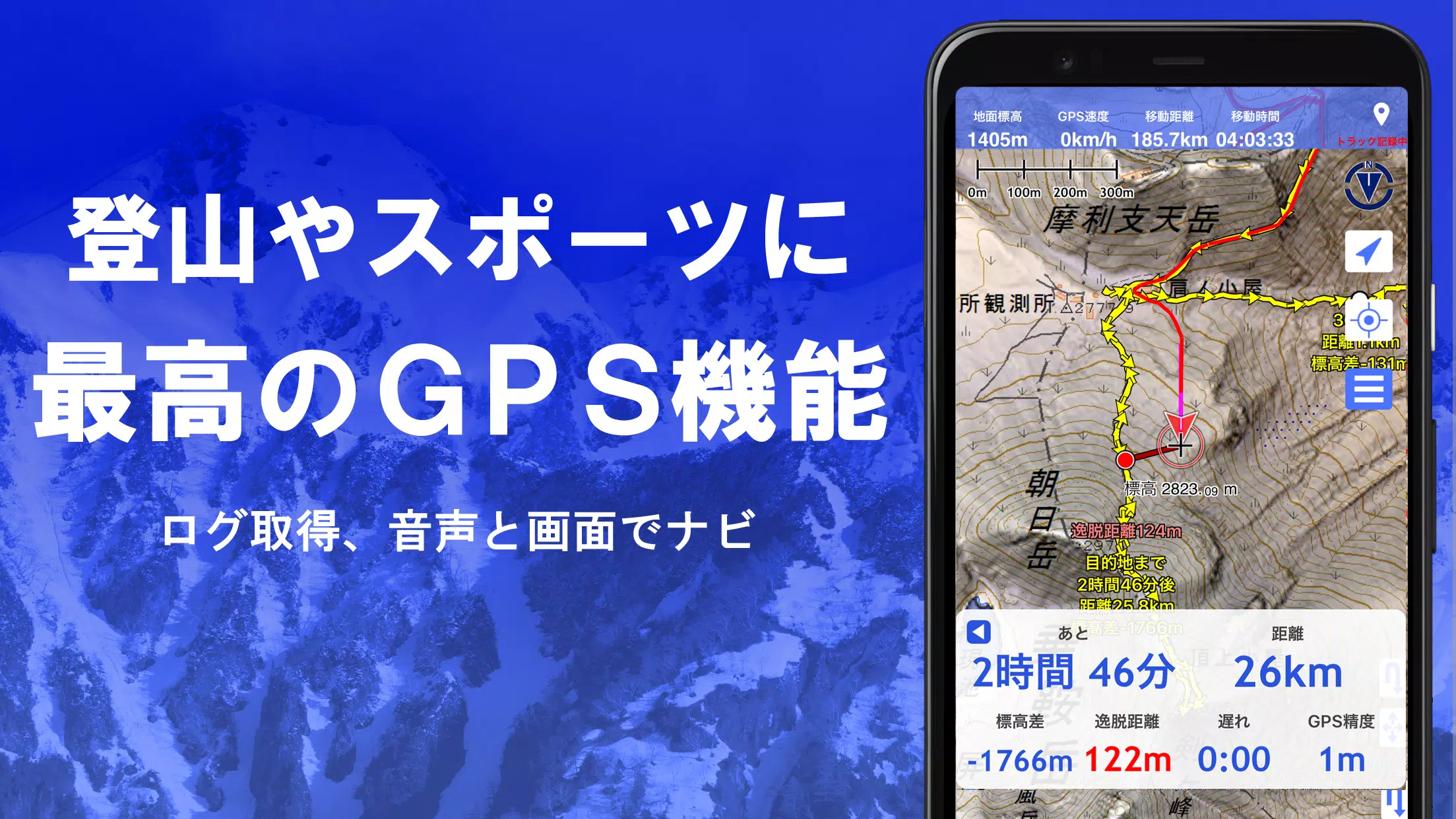
Super Terrain is a powerful mapping application boasting over 100 map types, including Geographical Survey Institute maps, optimized for diverse uses from urban exploration to challenging mountain climbs. Winner of the 2018 Japan Cartographic Society Award for Best Work, Super Terrain offers unparalleled features:
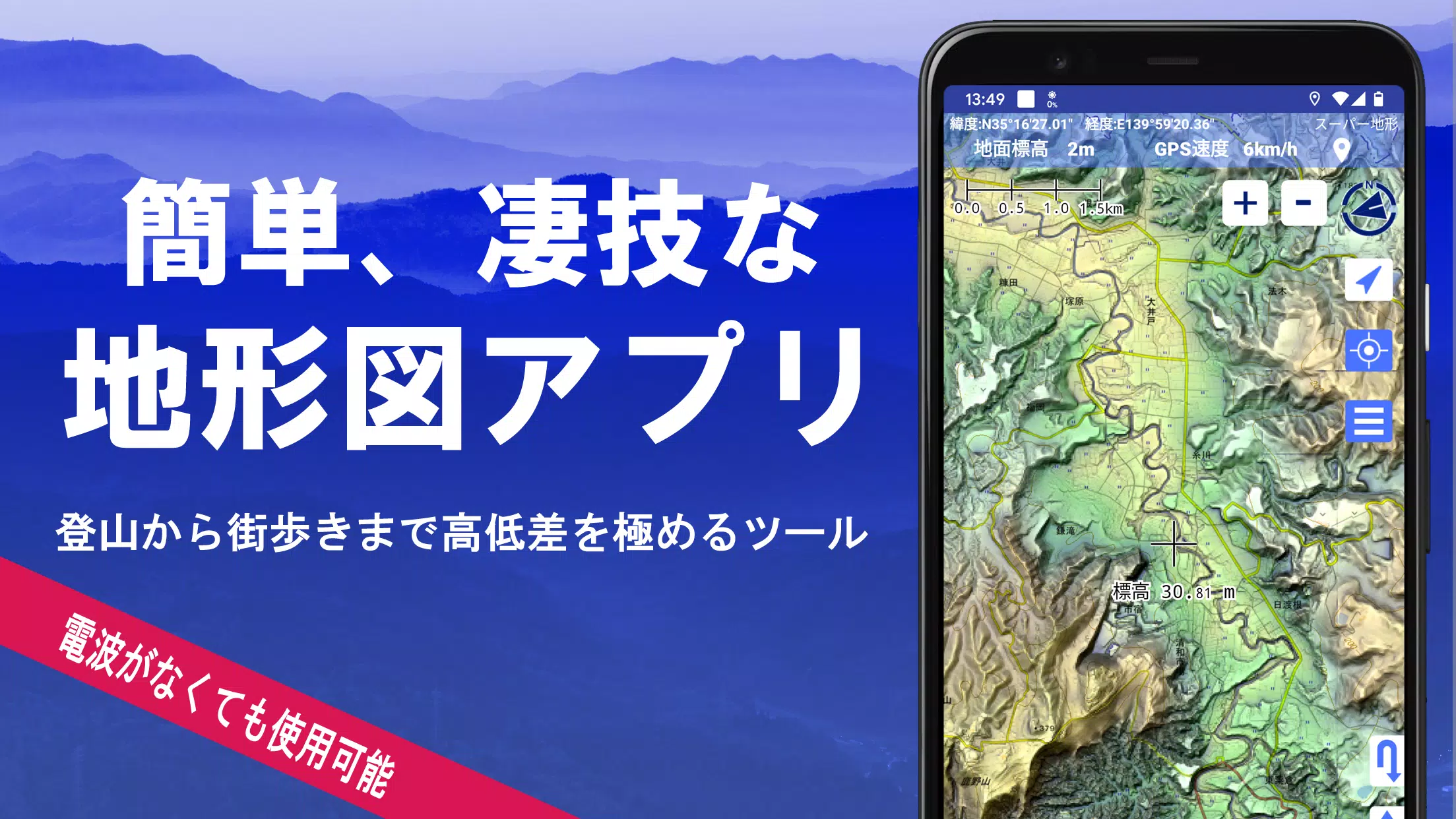
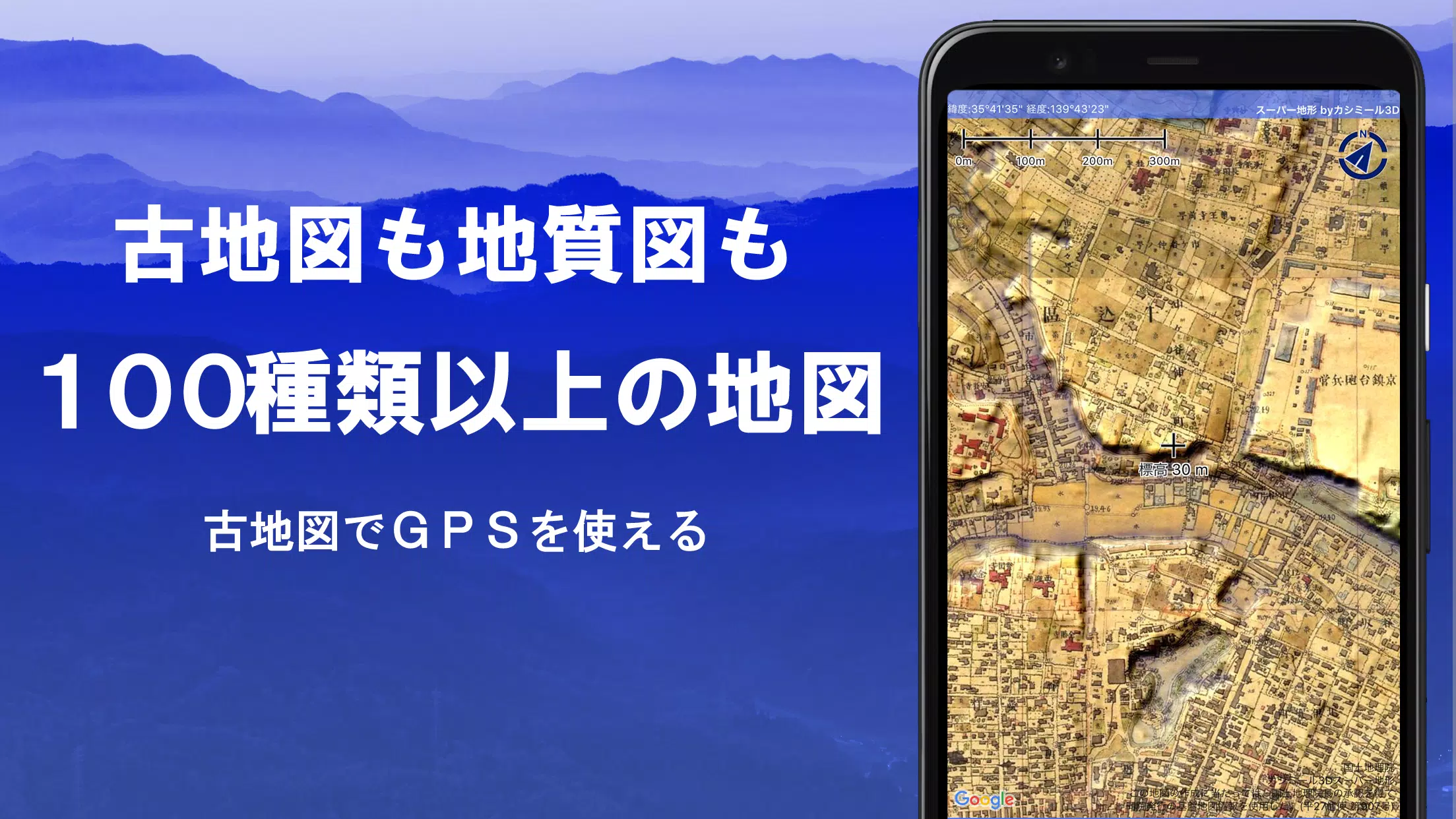
1. Extensive Map Selection: Access over 100 maps and combinations, including proprietary super topographic data, Geospatial Information Authority of Japan maps (topographic, geological, historical), and hazard maps. Aerial photography coverage varies by age; "Latest" and "around 1974" offer the broadest coverage. A 5-day free trial of super terrain data is included.
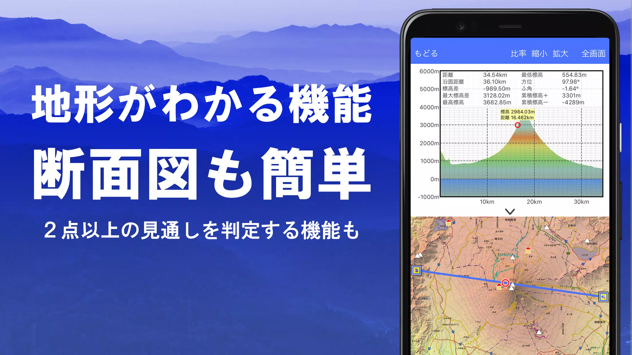
2. Cross-Section and Visibility Analysis: Effortlessly create cross-sectional views at any map point, incorporating Earth's curvature and atmospheric effects. Integrates building data (where available) for complete visualizations. Ideal for route planning, communication visibility checks, and terrain understanding.
3. Customizable Elevation Palette: Personalize your map experience with the elevation palette function, adjusting background colors and gradients in 1cm increments.
4. 360° Panoramic Views: Identify mountains, view sun and moon positions (including moon phases – perfect for observing Diamond Fuji and Pearl Fuji!), and pinpoint GPS locations with our 360° panoramic view function, linked to your smartphone's compass. Works internationally.
5. Robust GPS Functionality: Utilize high-precision GPS for location tracking and route recording. Analyze tracks graphically, viewing elevation changes, speed, time, and elapsed time. Point alarms provide voice and sound notifications upon approaching pre-set points. Share map center coordinates with NaviCon. Photo association with points is also supported.
6. GPS Track Playback: Review recorded tracks comprehensively, with automatic photo matching based on timestamps. Photos are displayed on the map with a tappable icon.
7. Versatile GPS Navigation: Navigate pre-set tracks with Track Navi, receiving voice or alarm alerts if you deviate from the route. Supports route navigation for urban use and point-to-point navigation.
8. GPS Data Editing: Manage point, route, and track data efficiently using a user-friendly tree-structured folder system. Create tracks directly on the map, and import/export GPX data.
9. Offline Map Access: Download maps in bulk for offline use in areas without cellular signal. A caching function further enhances offline capabilities.
10. Map History: Easily revisit previously viewed map locations.
11. Custom Map Support: Import and use custom maps created with Kashmir 3D's map cutter (images should be approximately 256 x 256 pixels).
12. GeoJSON Compatibility: Display and edit GeoJSON data (points, linestrings, polygons), and create new shapes.
13. Printing and PDF Export: Generate printouts or PDFs of any map area at a specified scale.
14. App Integration: Exchange data via GPX, KML, and GDB formats with other applications and Kashmir 3D software.
15. Data Backup and Restore: Back up and restore all app data (excluding map caches) to prevent data loss. Automatic Google Drive backups are available.
16. In-App Purchases: Some features (super terrain data, GPS track functions, cross-sectional views) require in-app purchase (780 yen/year). Purchase also increases place name search results. A 5-day free trial is included. Automatic renewal can be managed via Google Play.
17. Terms of Use: Please review the terms of use and safety precautions regarding GPS usage and battery life within the application. A navigation guide is available at https://www.kashmir3d.com/online/superdemapp/superdem_navi.pdf. Note that some smartphone power-saving functions may interrupt GPS tracking.
Download Super Terrain today and experience the future of mapping and navigation!
导航工具非常实用! 🗺️ 超过100种地图类型适合各种用途,从城市探险到山地攀登都很棒。
非常に便利なマッピングアプリです! 🗺️ 100種類以上のマップタイプがあり、街探検や山登りに最適です。
도시 탐험부터 산악 등반까지 다양한 용도로 사용할 수 있는 맵 앱입니다! 🗺️ 여러 종류의 지도가 있어 매우 유용합니다.
Extremely useful app for navigation! 🗺️ Over 100 map types are perfect for both urban and outdoor adventures. Great tool for hikers!
Una aplicación muy útil para navegación! 🗺️ Más de 100 tipos de mapas son ideales tanto para ciudades como para montañas. Excelente herramienta para excursionistas.


-
 Duet Night Abyss Aug 26 2025 Livestream to Reveal Global Release Date
The developer of Duet Night Abyss, Pan Studio, will reveal the game’s global launch date during a live stream on August 26. Learn more about what to expect from the upcoming release.Duet Night Abyss Developer to Announce Release DateLivestream Coming
May 22,2026 -
 Monopoly GO: Today\'s Event Schedule & Best Strategy (January 15, 2025)
Quick LinksMonopoly GO Events Schedule for January 15, 2025Best Monopoly GO Strategy For January 15, 2025With less than two days remaining before the Jingle Joy album concludes, Monopoly GO players are rushing to finalize their collections and secure
May 21,2026 - ◇ Stellar Blade Leak Shows PC Date, Boss, Outfits May 20,2026
- ◇ "Super Mario Party Jamboree" Sales Soar May 18,2026
- ◇ Alolan Ninetales Stars in Pokemon TCG Pocket Event May 16,2026
- ◇ Mastering Mecha Fire: Top 10 Winning Strategies May 12,2026
- ◇ Square Enix to Launch Octopath Traveler 0 for Switch & Switch 2 May 05,2026
- ◇ ILL release date announced May 01,2026
- ◇ Miyamoto: Nintendo Is a Talent Agency of Characters Apr 29,2026
- ◇ Split Fiction Sells 2 Million Copies in One Week Apr 24,2026
- ◇ Ash & Snow: Cat Pop'n Match Is a New Game from the Makers of Isekai Dispatcher Apr 24,2026
- ◇ Dying Light: The Beast Release Date Unveiled Apr 23,2026


- 1 Pokemon GO Fest 2025: Dates, Locations, and Event Details Jan 08,2025
- 2 How to Get All Ability Outfits in Infinity Nikki Feb 28,2025
- 3 Pokémon TCG Pocket: Wonder Pick Date, Time, and Promo Cards – February 2025 Mar 03,2025
- 4 Black Myth: Wukong Tops Steam Charts Days Before its Launch Jan 07,2025
- 5 Ukrainian Internet Stalled as 'S.T.A.L.K.E.R. 2' Release Overwhelms Dec 30,2024
- 6 inZOI, a Korean Sims-Like, Delayed to March 2025 Mar 01,2025
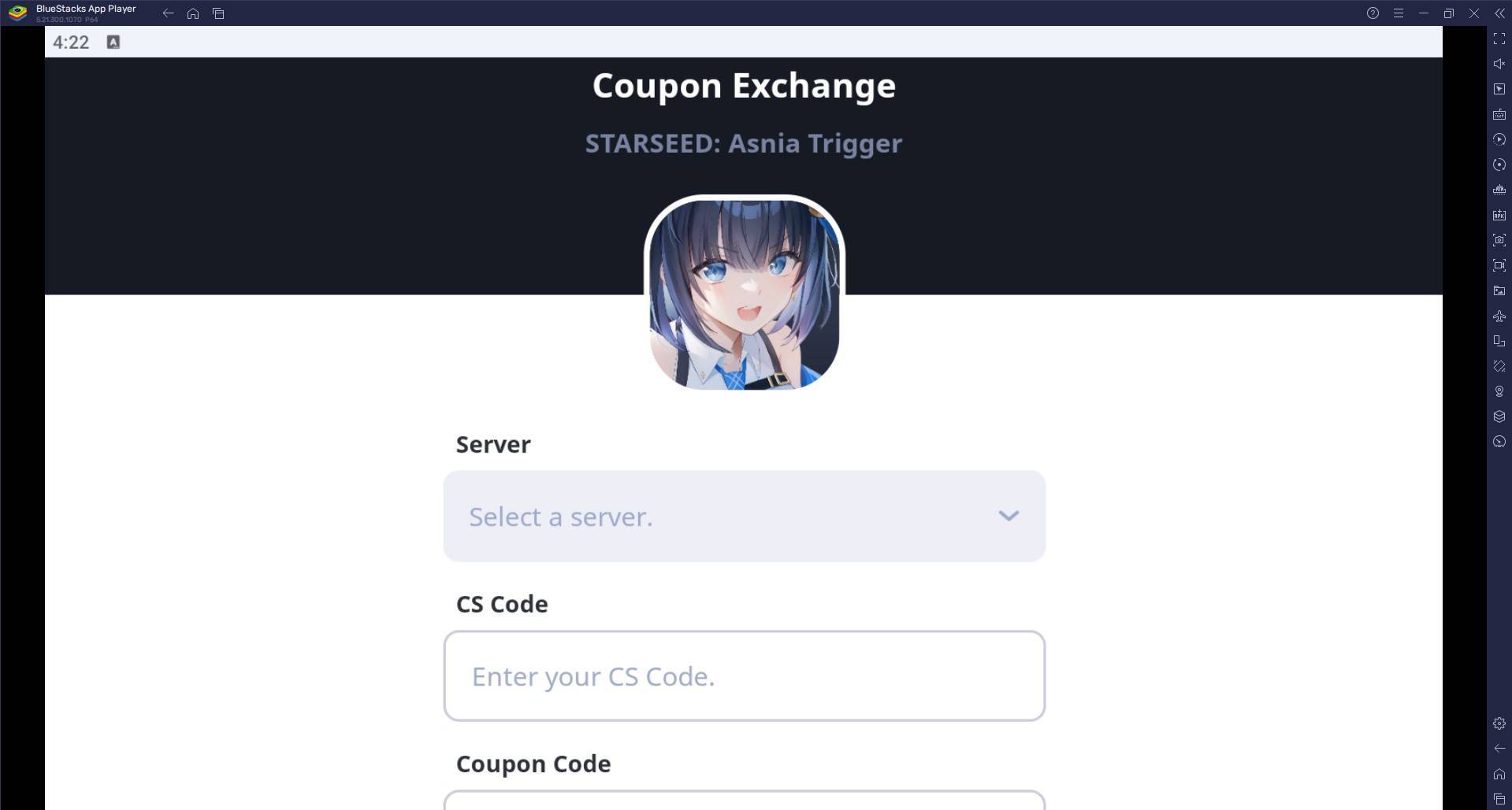
- 7 Starseed Asnia Trigger Codes (January 2025) Mar 06,2025
- 8 Assassin's Creed Shadows Postponed to March 2025 for Enhancements Feb 21,2025


-
Budgeting & Investing: Your Guide to Financial Apps
A total of 9
-
Addictive Hypercasual Games for Quick Play
A total of 10
-
Best Role Playing Games for Android
A total of 10